Commentary on SEA
Commentary on SEA as it relates to Policy W20
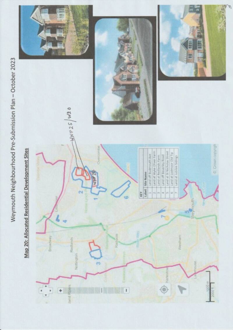
1. The SEA report is listed at https://www.weymouthtowncouncil.gov.uk/wp-content/uploads/2024/12/Weymouth-NP-SEA_Environmental-Report-November-2024.pdf in the documentation submitted to DC. It is listed as “November 2024”, is very similar to the previous versions submitted on 5 September 2023 and 25th October 2023. This version is dated 29th November 2024, was listed on the agenda for the WTC meeting on 20 November 2024 and was authorised by AECOM on 6 December 2024. It was, therefore, not available, as a key document, to WTC Full Council, or considered by them, when they voted to submit the WNP to DC. The fundamental flaw with this document is that it only considers 41% of the capacity of the site, 112-135 homes, instead of the 250 allocated in the WNP and the 270 desired by the developer is his REG14 submission.
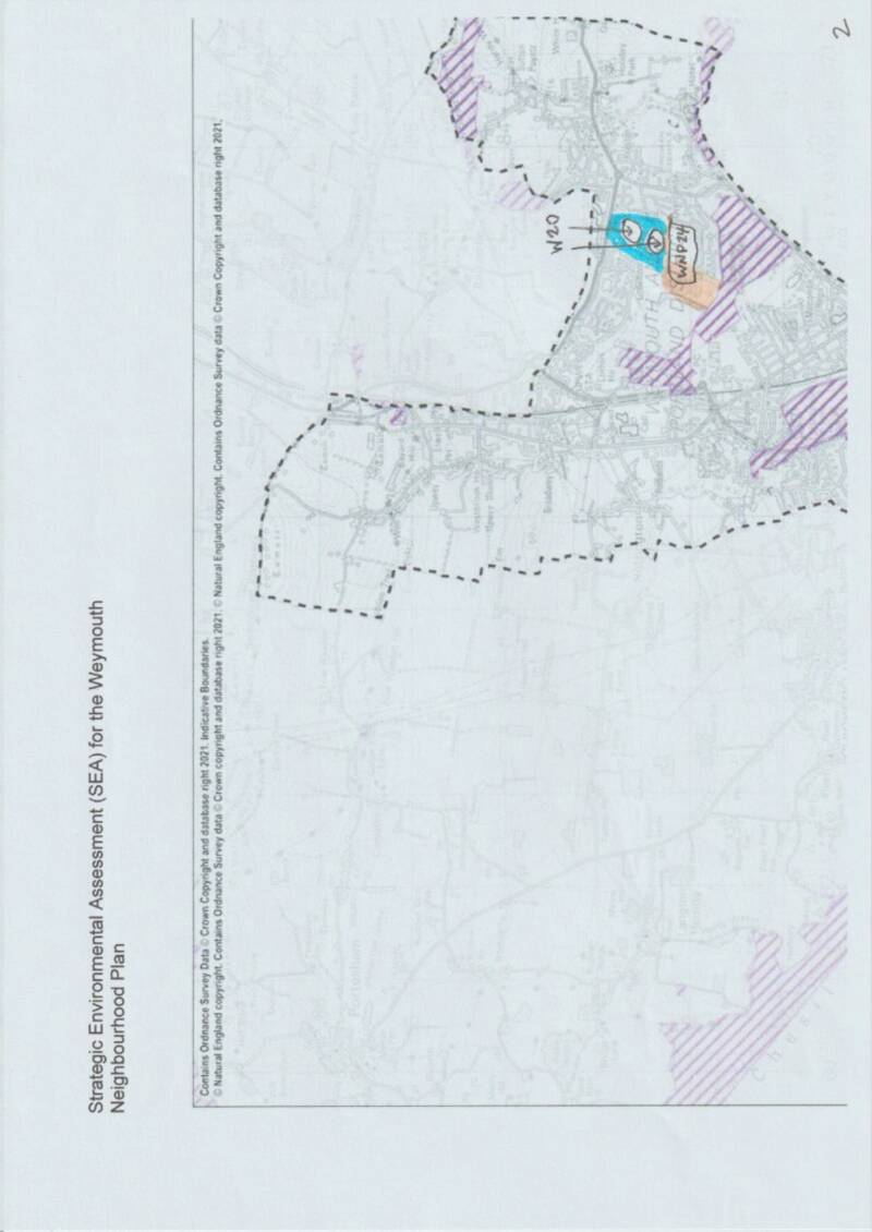
2. In considering why policy WNP24 was dropped from WNP but the adjoining site WNP25 continued to go forward as W20, it is vital to consider the SEA.
3. This is because it was confirmed by WTC that the reason for dropping WNP24 was due to SEA reasons. This is confirmed by document https://www.weymouthtowncouncil.gov.uk/wp-content/uploads/2024/11/Compendium-of-Policy-Changes-to-Pre-Submission-Plan-November-2024-1.pdf at page 2. This document has not been submitted to DC as part of the package for consideration by The Inspector. It says: “Policy deleted as a result of concerns raised regarding Biodiversity, Community Well-being, Landscape, and Transportation in the SEA, Dorset Council and by residents”. These SEA reasons were further confirmed on 10 February 2025 by the chair of the SG, Cllr Northam, in his address to a public meeting of residents. This recording is at https://drive.google.com/file/d/18jZAN8fHllHgg4Dy_9xuaVAOWqaHQKQn/view?usp=drivesdk at 26minutes and 36 seconds. WNP24 and the new W20 are essentially the same field and therefore the SEA conclusions should be similar.
- BACKGROUND
Neither WNP24/WNP25/W20 were mentioned in the extant Dorset Local Plan 2015. In February 2017 they both appeared as Site G in the Sustainability Appraisal Issues and Options https://www.dorsetcouncil.gov.uk/documents/35024/296265/Sustainability+Appraisal.pdf/86f627ea-0374-adf7-a5e3-a19101a23f50 as a combined Site G on page 48. They came forward into the WNP as 2 sites because of the different ownership. At page 50 of the 2017 report, it shows the conclusions as being 6 Red Flags out of 11 criteria. Biodiversity, Landscape and Climate Change scored Red Flags and Community scored “neglible effect”. Transportation was not considered. Flooding scored a Red Flag in its own right along with Climate Change but was subsumed into “Climate Change” alone for the 2024 report. This is peculiar because the 2017 report listed at para 8.1.7 on page 51: “The River Wey and its tributaries, and the flood plains associated with this river system and other surface water features surrounding Weymouth, occupy large areas of the land surrounding the town. Development would result in adverse impacts upon water quality and expose property and residents to flooding in areas to the west of Broadwey and Redland (areas I and K), in those areas surrounding the Lorton Valley Nature Park (areas F and G), around Preston (areas A and B) and the coastal areas to the West of Weymouth (areas M).”
After this 2017 Review, in 2018 came forward the Sustainability Appraisal Preferred Options conclusions https://www.dorsetcouncil.gov.uk/documents/35024/296265/20180802+-+Sustainability+Appraisal+Preferred+Options+%28FINAL%29.pdf/4c515ee5-159c-4b10-d646-24ec390b9735 which was to form policy until discontinued when West Dorset DC ceased and DC was formed. In this, at page 80, the combined site G had disappeared and basically only WNP24 came in as Site W1. However, for reasons unknown, “Land at Wyke Oliver Farm” appeared on page 83 as a policy WEY14 and no map at all was contained in this document to show its location. The evolution of “WEY14” has been tracked over the years as:
- West Dorset and Weymouth draft Local Plan June 2012 WEY14 was “land to the south of Lorton Lane”
- Ditto June 2013 WEY14 was “Bowleaze Cove”
- Doesn’t figure in the extant lawful Local Plan at the moment (2015)? Page 149 shows WEY14 as “Bowleaze Cove”
- Appears in the 2017 Local Plan Sustainability Appraisal Issues and Options Review at pages 48-52 as “Area G” with no other designation but shown on Map
- Appears in the 2018 Local Plan Sustainability Appraisal Preferred Options Reviews at pages 80-85 as “WEY14 Land at Wyke Oliver Farm” but is not shown on any map in that document for clarification as to location or content
- Appears on page 3 of Dorset Environmental Records Centre Ecological Survey September 2021 as WEY14 “Redlands Farm, Wey Valley”
- Appears in Dorset Council Local Plan consultation 2021 summary of responses – Weymouth on page 24 as WEY14 reverting back to “Land south of Wey Valley”
- WEY14 Appears in the AECOM WNP Site Options and Assessments Report January 2023 on page 20 as “Bowleaze Cove”
- Ditto page 35 as WNP14
- Ditto page 36 as LA/WEYM/012 as “Wyke Oliver Farm (North)
- Appears in draft of WNP as Policy WNP25 Land at Wyke Oliver Farm North
- Appears in statutory document WNP as W20 Land at Wyke Oliver Farm North
- Appears in statutory consultation WNP document Viability Report on page 2 in contents as WNP25 Land at Wyke Oliver Farm North
- Appears in statutory consultation WNP document Viability Report in unnumbered pages Annexe 3 over many pages as WNP14 Land at Wyke Oliver Farm North
- BIODIVERSITY
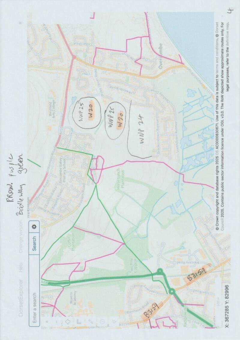
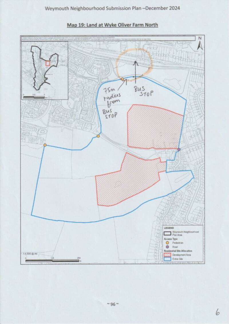
We rely on pages 31 and 53 of the SEA Statutory Report, which compares Biodiversity. This was given a Red Flag to WNP24 and an “uncertain” flag to WNP25. It was given a Red Flag to the joint site in the 2017 Appraisal and a Red Flag to the 2018 Preferred Options for WNP24. In the Statutory SEA Document for 2025 it continues to be shown for WNP24, although this site had been dropped, at page 31 as a Red Flag and now downgraded for WNP25/W20 at page 53 as an “uncertain” effect. On reading, both are incredibly similar in description with regard, for example, to proximity to the SSSI. The site indicated for WNP24 on page 30, by this time, was no longer accurate as far as Biodiversity was concerned because it had been agreed to drop fully one-half of the site at the west and give it over to the SSSI, restricting development to just the portion north of Brackendown Avenue. So, the BAP Priority Habitats took little or no prominence and both sites should, probably, have scored “uncertain” and neither “Red”. This can be better visualised at the 3 maps on pages 1-3 of the attached pdf.
Much is made about the transfer of 31.9ha of land (WNP24 8.5ha and WNP25 23ha) to the Lorton Valley Nature Park as shown in the Statutory Bundle https://www.dorsetcouncil.gov.uk/documents/d/guest/change-summary-wnp-policies-post-reg-14-november-2024 at pages 2 and 4. This is simply no longer the case once WNP24 was dropped because the transfer of land by the owners was conditional on development going ahead. This shown on Map 2 in the attachment. The portion coloured orange must now be considered lost for the LVNP and, as a result, W20 land for either Dorset Wildlife Trust or LVNP coloured blue is no longer contiguous with the Reserve and there is no evidence to show that it will be viable in isolation. There is no certainty at all that residents in W20 will have access to LVNP as it stands, over the orange land, which will now presumably remain farmed under the ownership of Southdown Farm. At page 82 of https://www.dorsetcouncil.gov.uk/documents/d/guest/reg-14-analysis-final-28-02-2024 Dorset Wildlife Trust stated: “These proposed allocations are those which are anticipated to have the potential for greatest impacts on biodiversity.” The assurance of this transfer formed the basis of DC’s comments in Reg 14 about WNP25 and is now unsafe.
6. Community Wellbeing
We rely on pages 32 and 54 of the SEA Statutory Report, which compares Community. This was given a Red Flag to WNP24 and an “uncertain” flag to WNP25. It was given a “neglible” to the joint site in the 2017 Appraisal and the same to the 2018 Preferred Options for WNP24. In the Statutory Document for 2025 it continues to be shown for WNP24, although this site had been dropped and it is not clear why AECOM would still want to include it, at page 32 as a Red Flag and “uncertain” WNP25/W20 at page 54. Some of the differences are:
- WNP24, but not WNP25/W20 says: “new development distant from the town centre”. Actually, WNP25/W20 is as, or more, distant from Weymouth as can be seen from the attached maps. This is explored more below under “Transportation”.
- For W20, this section of the SEA at pages 52 and 54 falsely lists it as: “the potential to deliver between 112-135 new homes”, whereas Policy W20 calls for 250 and the developer for 270 homes. Its categorisation as “uncertain” is therefore deeply flawed.
- WNP24 gets a Red Flag: “Allocating it for development would contribute to the closing of the gap between Overcombe to the south-east and Littlemoor to the north. This could lead to coalescence effects if further development were to come forward to the north and west of this site.” This effect is missing entirely from WNP25/W20, which is actually to the north. The coalescence effects of W20 are all too obvious.
- WN24 confirms: “it would be difficult to access the servives (sic) and facilities in Weymouth.” W20 says: “there is uncertainty over how well it will connect to the main settlement of Weymouth”. This is explored more below under “Transportation”.
7. Landscape
All 4 documents from 2017, 2018, WNP24 and WNP25/W20 score this as a Red Flag, primarily for the reasons of coalescence with Littlemoor, loss of Green Gaps and loss of Wildlife Corridor, in contravention of other policies within WNP such as W14 9.21: “Any development proposals that are considered permissible should be accompanied by a landscape character assessment to establish that there will be no adverse visual impact on the character and sensitivity of the landscape”. In a different AECOM report https://www.weymouthtowncouncil.gov.uk/wp-content/uploads/2023/01/Weymouth-Neighbourhood-Plan-Site-Assessment-Final-Report.pdf at page 165 their SHLAA conclusion was: “The site is located outside the development boundary and within land of local landscape importance and an important open gap. Unacceptable landscape impacts. An unsuitable site.
Suitability: The site is located outside the development boundary and within land of local landscape importance and an important open gap. Existing development is already intrusive; particularly areas on upper slopes. Unacceptable landscape impacts. Farm buildings could be converted, development unacceptable in undulating and elevated open landscape”
8. Transportation
We rely on pages 34 and 56 of the SEA Statutory Report, which compares Transportation. This was given a Red Flag to WNP24 and an “uncertain” flag to WNP25. It was not given as a criterion in either the 2017 or 2018 reports referred to above.
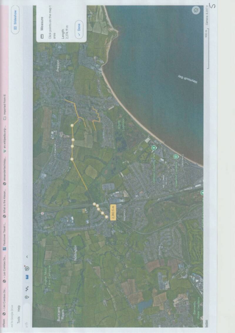
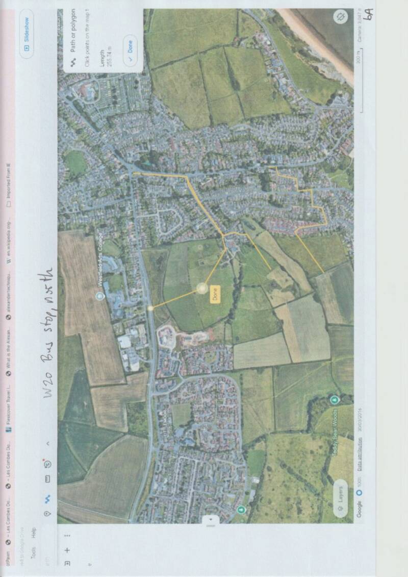
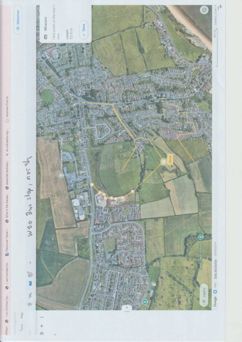
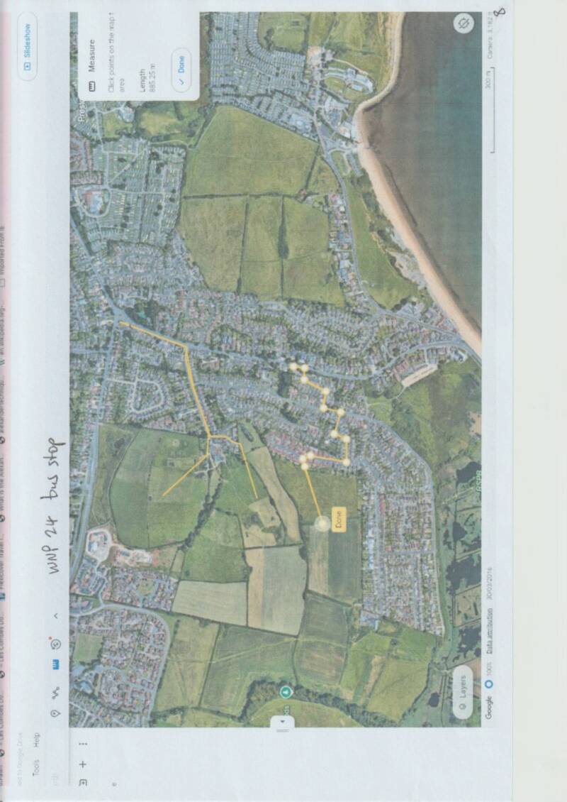
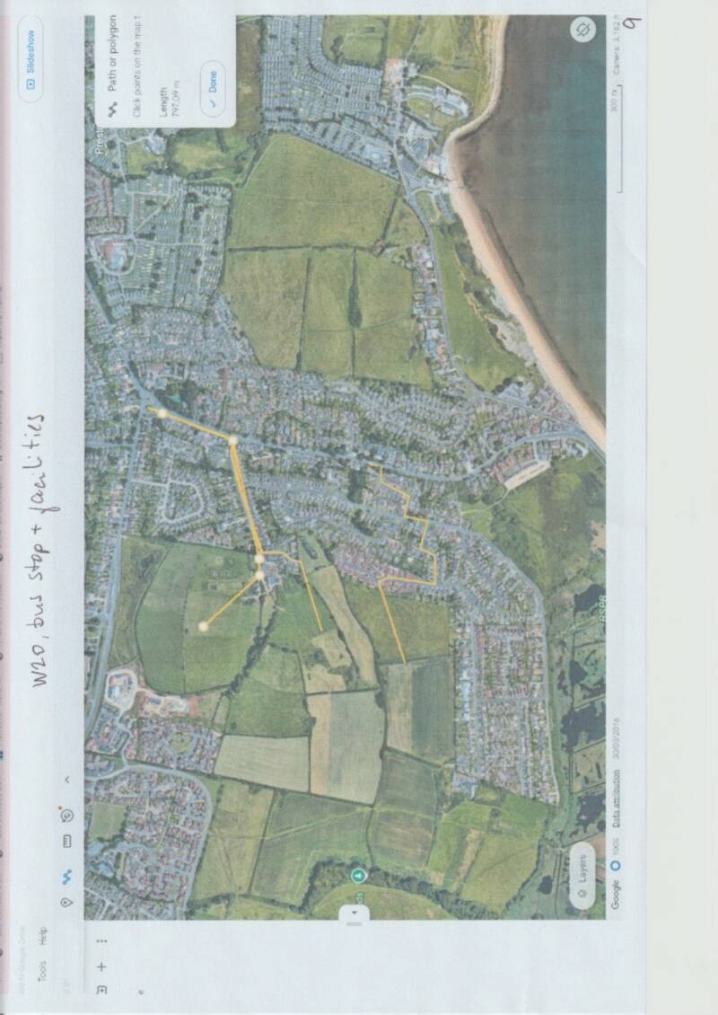
A. It is a nonsense in both WNP24 and W20 that: “This allows for access to services in the centre via the B3159.” This is illustrated on maps 4 and 5 of the attached pdf. If the footpaths were even in existence (which they are not) google earth shows it to be well in excess of 2km by foot to reach the B3159. Nor is the B3159 reachable by bus. It is a nonsense (map 6) that “There are bus stops in proximity to the northern site boundary – approximately 75m to the north”. The bus stop to the north is shown on Map 6A as 255m from the centre of the northern part of the site and either impossible or much further from the southern part of the site. There are no services from this stop which go along the B3159. Just a few times a day it might be possible to catch a bus to Dorchester from this stop, then change route further along the line at Littlemoor for the B3159 bus to Weymouth. Even the bus stop shown closest to the northern part of the total site (the southern part of the site is much further) would also involve great elevation changes of at least a 10-storey building, make it further unwalkable. No account has been taken of changes in elevation in the area. The bus stop at Charlbury Corner, for example, is at an elevation of 13m and the top of the site is 40+m. Walking around the hills would add many hundreds of metres instead of the “as the crow flies” approach (Map 7 at least 723m). Map 8 shows that the statement in WNP24 on page 34 is misleading that the nearest bus stop was 740m away. This might have been to the entry of the site, but Map 8 shows the median point to be 885m away and the end of the site to be about 1000m away.
B. Page 82 of WNP at 9.30 suggests that a “walkable” neighbourhood should have facilities “within 800m”. Dorset Council has no policy on this in NP’s since each site is different. This particularly applies to W20 with the very large changes in elevation, making both walking and cycling very challenging. Policy suggested by Sustrans in 2022 https://www.sustrans.org.uk/our-blog/research/walkable-neighbourhoods-building-in-the-right-places-to-reduce-car-dependency/ was that “LPAs should develop Supplementary Planning Documents that set accessibility standards based on 800m walking and wheeling distances to key services, and 400m to bus stops.” Map 9 shows the practicable bus stop at Charlbury Corner to be no less than 800m away using a mixture of “crow flies” and existing roads, evidently final site design will make this much further.
C. In giving an “uncertain” status to W20, the SEA report concludes there will be: “high private vehicle use” to the site for the above reasons, in contradiction to Policy W51, Traffic Impact: “Development proposals to reduce the volume and impact of motor vehicles” therefore making the site unsustainable for Transportation.
9. Climate Change and Flooding
There is no dispute that Flooding is the single greatest threat to Weymouth through Climate Change. The DC comment on page 196 of their Reg 14 says under para 194: “Flooding – a lack of criterion referring to flood risk is a concern”. At page 197 para 202 Dorset Council concluded its Reg 14 with: “It is therefore recommended that these site constraints are investigated in advance of formal site allocation and co-ordinated through ‘initial’ master planning work reflecting an iterative process to site design”. The site has been formally allocated and there is no sign of this work having been done.
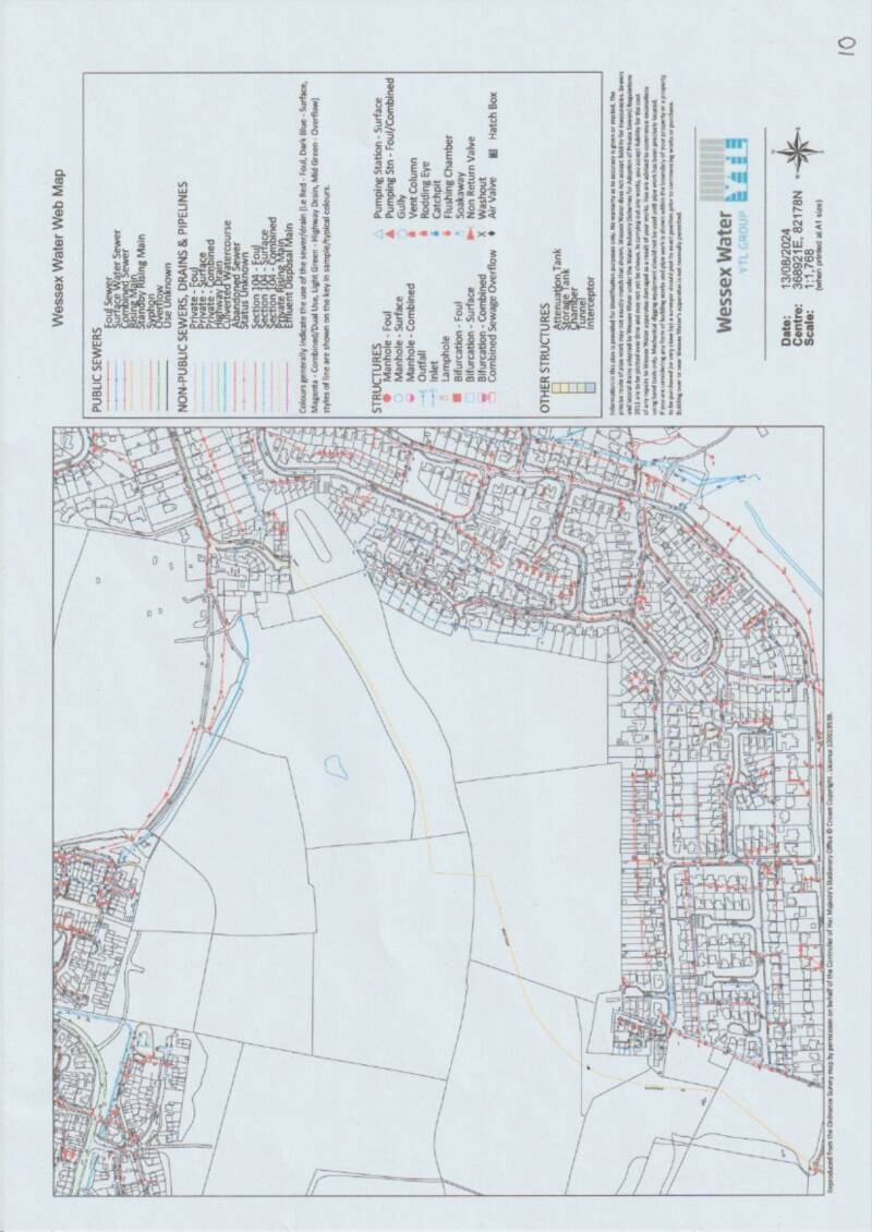
Strangely, the SEA only makes oblique reference to this and denies Flooding a separate chapter, even though it was a separate chapter in both the 2017 and 2018 Local Plan Reviews. On page 54 under Land, soil and water resources it says: “there are no watercourses on the site.” This is not true. The valley existing where the southern slope of the northern sector of the site drains together with the northern slope of the southern sector is a watercourse. It drains into a culvert at the Farm, whence it is ducted underground in a culvert for over 1000m into the Lodmoor Marshes. It cannot cope with serious rainfall and was notably the cause in the 1980’s of the Farm being flooded, a wall demolished to allow the internal water to escape, which flooded nearby houses. Buried within this valley is a pressurised sewer main from Littlemoor to Lodmoor Marshes, see schematic from Wessex Water on Map 10 in the attachment, where the sewer is orange and the second culvert blue containing surface water run-off from Littlemoor. Wessex Water confirm this as “Draft Policy WNP25: Land at Wyke Oliver Farm North There is an existing pressured pumping (rising main) which crosses the proposed development site. There must be no building over or near the main. This is to ensure that buildings do not damage the pipe and to enable continued access for future maintenance and repair" at page 3 of their Reg 14 submission https://www.dorsetcouncil.gov.uk/documents/d/guest/wessex-water-response-weymouth-neighbourhood-plan-reg-14-consultation-feedback-form-dec-2023_redacted
There is a small area of Flood Zone 3 on the site (where the 2 slopes drain together) and Map 14 on page 65 of WNP makes this clear, along with the stretches of Wyke Oliver Road which are Flood Zone 3 and then the whole of the transit down to the marshes.
On the first page at para 5 of https://www.dorsetcouncil.gov.uk/documents/d/guest/change-summary-wnp-policies-post-reg-14-november-2024 it says: “A significant concern raised by residents, and the Environment Agency has been the Flood Risk both from climate change increasing wave surge, sea levels, rain and storm incidence”. This relates only to Weymouth Town Centre and no work was undertaken to consider the other 2 major flood risks to the east of the town centre and at W20. In their Reg 14 https://www.weymouthtowncouncil.gov.uk/wp-content/uploads/2024/11/FULL-Reg-14-Response.pdf when considering site WNP25/W20 Wyke Oliver the Environement Agency said at page 243: “A key principle of the planning system is to promote sustainable development. Sustainable development meets our needs for housing, employment and recreation while protecting the environment. It ensures that the right development, is built in the right place at the right time. To assist in the preparation of any document towards achieving sustainable development we have identified the key environmental issues within our remit that are relevant to this neighbourhood area and the proposed allocated sites and provide guidance on any actions you need to undertake. We also provide hyperlinks to where you can obtain further information and advice to help support your neighbourhood plan. Flood Risk The neighbourhood plan area and the some of the proposed allocated sites are located within Flood Zone 2 and 3. In accordance with the National Planning Policy Framework (NPPF) paragraphs 159-164, we remind you that the Sequential Test should be satisfied as your plan is proposing development or promoting growth. This should ensure development is directed to the areas of lowest risk of flooding, taking climate change into account. The application of the Sequential Test should be informed by the Local Planning Authority’s Strategic Flood Risk Assessment (SFRA).” The SG of WNP acknowledges this at pages 4 and 5 of document https://www.weymouthtowncouncil.gov.uk/wp-content/uploads/2024/11/Reg-14-Analysis-Final-28.02.2024.pdf There is no evidence in the WNP that this advice from EA, particularly sequential testing and FCERM, has been carried out, nor the advice to consider “Issues of contamination and flood risk at Lodmoor”. It further said: “ensure policies …..WNP17, WNP20, WNP39…..” but this has not been done nor carried through the changed Policy Numbers in the formal submission of WNP and not applied to Policy W20.
The EA is clear about Climate Change above and the latest guidelines are that surface water flows 45% above today’s values must be incorporated. This has not been done in spite of proven history of flooding to local houses from the Preston Brook and overwhelmed culvert of more than 1000m leading to Lodmoor Marshes.
The Dorset Council Flood Risk Management Team at page 232 in their Reg 14 response said: “Land at Wyke Oliver Farm North Due to existing downstream flooding issues and constraints in the form of a long stretch of culvert, rainwater harvesting, and water re-use should be the first priority for inclusion within the proposed surface water management strategy. This could help to reduce the volumes of surface water making its way downstream and therefore reduce the risk of flooding. Applicant must demonstrate that the SuDS hierarchy has been followed and infiltration must be prioritised as the proposed means of surface water management. A developer will need to demonstrate that they have carried out site specific ground investigations. Infiltration rates are likely to vary across the site due to the varying geology and careful consideration will be required in order to locate SuDS features appropriately. Care should be taken to carry out infiltration testing to the standards set in BRE Digest 365 at the depth and location of any proposed infiltration-based SuDS. Groundwater monitoring across the course of the year will be required in order to demonstrate that groundwater will not impact the functioning and reduce the attenuation volume of any proposed soakaway features. Attenuation of surface water and a restricted discharge to the adjacent watercourse may be considered in the event that infiltration is proven not to be viable but as there is a significant constraint in the form of a long stretch of downstream culvert the LLFA may require additional restrictions on surface water discharge above and beyond greenfield rate in order to minimise risk to downstream areas. Open SuDS must be prioritised with multifunctional benefits including improvements to amenity, biodiversity and water quality”. In their response to this, the SG wrote at page 106 of:
https://www.dorsetcouncil.gov.uk/documents/d/guest/reg-14-analysis-final-28-02-2024 “Refer, in the supporting text, to comments by the Flood Risk Management Team and the required evidence and supporting documents”. This has not been done in the WNP under policy W20.
The residents have consistently brought this to the attention of the SG but, if there were any doubt, this is the text which Cllr Orrell, Mayor of Weymouth and respected GP, wrote in January 2025: “I note the references to climate change and flooding. I fully comprehend the science in this area and the various impacts calibrated by degrees of warming.
Preston is certainly at risk. We have had briefings from the Environment Agency over the last decade which set out the firm predictions. I grew up in the area with my parental home at 45 Preston Road, just up from the old Streamside Hotel ( where we had our wedding reception). The stream it was beside also ran through our garden. I have seen it flood on several occasions and reach nearby bungalows built in the flood plain. The whole valley is at risk up to my old surgery near Chalbury corner. The sea wall will not last the century. The whole matter needs to be an area for substantial investment and redesign even without any new houses."

Create Your Own Website With Webador